

The Atmosphere
The air is constantly changing as you climb higher in the atmosphere. The atmosphere is the layer of gases that surround the earth and it has many different functions. It is a protective boundary that protects the earth from the harsh extremities of outer space and it also provides the perfect living conditions for us to live in. It protects us from meteoroids and high energy radiation from space. It also keeps heat in to regulate temperatures. It is composed of various different gases.The atmosphere is composed of nitrogen, oxygen, water vapor, and other gases in which tiny liquid and solid particles are suspended. Oxygen and Nitrogen make up 99% of clean, dry air. The atmosphere exerts pressure because it has gravity. Air pressure is the force exerted by the weight of a column of air on a surface and it is measured using a barometer. Air pressure and density have an inverse relationship with altitude. As altitude increases, air pressure and density decrease. The atmosphere has 4 layers. From the bottom up, they are the troposphere, stratosphere, mesosphere, and thermosphere. The troposphere contains a large majority of the water vapor and particles which are crucial in the formation of clouds. Weather (condition of atmosphere in a particular place at a particular time) occurs here. The temperature decreases as altitude increases. The stratosphere extends from about 12 kilometers to 50. The temperature there stays about the same from the boundary with the troposphere to about 20 kilometers high, but then it starts increasing. The upper stratosphere is home to the ozone layer, that is why it is warmer. The ozone layer absorbs UV radiation in sunlight and filters most of it out before radiation reaches earth’s surface. The energy absorbed is converted into thermal energy and this warms the upper stratosphere. The mesosphere begins at an altitude of 50 kilometers and extends to about 80 kilometers. Here, the temperature decreases as altitude increases. The thermosphere begins from 80 kilometers and there is no boundary that indicates its end. The temperature increases rapidly here because gas molecules absorb solar radiation. The ionosphere is not actually a layer of the atmosphere, but it has a bunch of charged particles. Molecules lose one or more electrons here as they absorb solar radiation. An aurora is a colorful display of light that occurs in the ionosphere when charged particles from the sun are attracted to the magnetic fields.
The Suns and The Seasons
Planet Earth is constantly moving in two different ways: rotation and revolution. Rotation is the spinning of earth on its axis and this causes day and night. Revolution is the movement of earth around the sun and it takes earth 365 1/4 days to orbit around the sun. Different parts of earth receive different amounts of sunlight and this creates latitude zones. There are 3 zones: tropic, temperate, and polar zones. If you are between 23.5 degrees north and 23.5 degrees south, you are in the tropics. If you are between 23.5 degrees north (or south) and 66.5 north (or south), you are in the temperate zone. From 66.5 degrees north (or south) to the poles. you are in a polar zone. This is because of the uneven distribution of the sun's light (solar energy). The seasons of earth are caused by the tilt of earth's axis at 23.5 degrees as it moves around the sun. A solstice occurs on 2 days each year when the sun is directly above 23.5 degrees north or south. In the Northern Hemisphere, the summer solstice occurs on June 21 and the winter solstice occurs on December 21. During the summer solstice, the days are longer and the northern hemisphere is receiving more sunlight, in the winter it is the opposite. During an equinox, neither hemisphere is tilted towards the sun and the days are about the same length. The vernal equinox occurs on March 21 and it marks the beginning of spring in the Northern Hemisphere. The autumnal equinox is on September 22 and marks the beginning of autumn.


Solar Energy and Winds
There is a lot of solar energy directed towards earth. Some is reflected back (30%), some is absorbed by the atmosphere (20%), and some is absorbed by the surface (50%). The atmosphere is heated by energy reradiated by Earth's surface. The energy incoming towards the earth is visible, however, the energy reradiated is infrared. Some gases radiate some absorbed energy back to the surface and this warms the lower atmosphere, this is known as the greenhouse effect. Within the troposphere, energy is transferred through radiation, conduction, and convection. Wind is a horizontal movement of air caused by differences in air pressure as air naturally flows from areas of high pressure to low pressure. This is caused by the uneven heating of the earth, as the air heats up, it expands and it rises. Cooler air sinks as it is more dense. Local winds blow over a short distance and two examples are land and sea breeze. Water has higher specific heat than land and during the day, solar energy heats land quicker and the less dense air expands and rises. This creates a low pressure area and the high pressure air over water flows towards land (sea breeze). At night the opposite happens when the cooler air over the land flows towards water, creating land breeze. Global winds blow over larger distances from a specific direction. They are caused by uneven heating from the sun over a larger distance. They move in large bands called convection cells. One example of global winds is trade winds. They are wind belts that are just north and south of the equator. In the Northern Hemisphere, they blow from northeast to southwest. Prevailing westerlies occur between 30 degrees and 60 degrees in both hemispheres and the polar easterlies extend from 60 degrees to the poles in both hemispheres. The Coriolis Effect is the curving effect Earth's rotation has on all moving objects, including global winds. Another thing that is a product of uneven heating is the monsoon wind. A monsoon is a wind system that is characterized by seasonal reversal of direction. They occur on a much larger scale and in a longer period of time than land and sea breeze. In the summer monsoon, warm and humid air from the ocean is blown onto the land and as the air rises, it brings heavy rain in South and Southeast Asia. The jet stream is a belt of high speed winds in the upper troposphere. They are caused by great differences in air pressure at high altitudes.
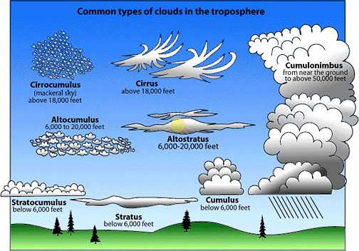
Water in the Atmosphere
Humidity is the amount of water vapor in the air. Relative humidity is the ratio of the amount of water in the air to the maximum amount of water vapor that can exist in that temperature. The dew point is the temperature where the air becomes saturated (when humidity is 100%). Water vapor condenses when the temperature goes below the dew point and it condenses as dew, frost, clouds, or fog. Clouds are a dense, visible mass of tiny water droplets or ice crystals that are suspended in the atmosphere. Clouds form as warm, moist air rises and water vapor condenses in the atmosphere. Clouds are classified by form and height. There are 3 main types: stratus, cumulus, and cirrus. There is also another type of cloud, fog, that nearly touches the ground. Stratus clouds are flat layer of clouds that cover much or all of the sky. Nimbostratus clouds produce steady rain (nimbo means it produces precipitation). Cumulus clouds are puffy white clouds that look like cotton balls. These are fair-weather clouds that you see on sunny days. Cumulonimbus, however, are dark, towering clouds that produce precipitation often with thunder or lightning. Cirrus clouds are thin, wispy, and white clouds. They are high altitude clouds that often do not produce rain. Precipitation occurs when water droplets or ice crystals join together and become large enough to fall without evaporating. The most common forms are rain, snow, sleet, hail, and freezing rain. Rain is liquid precipitation that forms in nimbostratus or cumulonimbus clouds. Snow is precipitation in form of ice crystals. Hail is solid pieces of ice of larger than 5 mm in diameter. It forms within cumulonimbus clouds when ice pellets are tossed up and down by rising and falling air. As this happens, ice combines with water droplets and freezes. Sleet is precipitation of ice of smaller than 5 mm in diameter. Sleet is rain that freezes. Freezing rain is rain that freezes after hitting surface.

Weather Patterns
An air mass is a large body of air that has fairly uniform physical properties. An air mass forms when a large body of air becomes fairly stationary over a region of Earth’s surface or as air moves over a large uniform region like an ocean. They are classified by where they form (land or water) and latitude of where they form. A front is the sharply defined boundary that forms when two unlike air masses meet. A cold front occurs when a cold air mass overtakes a warm air mass. Cold air remains closer to the ground than warm air because it is denser. These fronts force the warm air to rise and are often steep and move quickly. The rapid rise of warm air produces cumulus and cumulonimbus clouds. Strong winds, severe thunderstorms, and heavy precipitation are features of cold fronts, albeit for a short duration. A warm front occurs when a warm air mass overtakes a cold air mass. The warm air rises over the cold air mass. As warm air rises, stratus clouds are formed and steady rain accompanies these clouds. Once the front passes, warm air settles in and temperatures rise. Stationary fronts occur when two unlike air masses have formed a boundary but neither is moving. Stationary fronts often result in clouds, steady rain, or snow for several days. The final type of fronts, an occluded front, occurs when a warm air masses is caught in between two cold air masses. As the warm air rises and cools, water vapor condenses. As a result, cloudy skies and precipitation occur. A cyclone is a weather system with a center of low air pressure, winds circulate counterclockwise in Northern Hemisphere. As warm air at the center rises, pressure decreases. Because air moves from high pressure to low pressure areas, air spirals in toward the center. Cyclones are associated with clouds, precipitation, and stormy weather. An anticyclone is a weather system with a swirling center of high air pressure that circulates clockwise in the Northern Hemisphere. As air flows away from center, air from higher in troposphere descends and replaces it. When air descends, it warms and relative humidity decreases. They are associated with clear skies, very little precipitation, and generally calm conditions. A thunderstorm is a small weather system that includes thunder and lightning. They are accompanied by strong winds and heavy rain or hail. Thunderstorms form when columns of air rise within a cumulonimbus cloud. When a cold front forms, the cold air mass quickly lifts warm air mass up. Thunderstorms also form on hot summer days when buoyant air rises as part of convection current within an air mass. If the rising air is cooled to the dew point, and convection is strong enough, a thunderstorm can occur. Common features in thunderstorms are lightning and thunder. Lightning is a sudden electrical discharge in the atmosphere. There are positive charges that develop near top of cloud, and negative develop near base of cloud. When the potential difference becomes big enough, a discharge happens. Thunder is the sound produced by rapidly expanding air along the path of a lightning discharge. The air can be heated up to 33,000 degrees celsius. A tornado is a small, but intense windstorm that takes place in the form of a rotating column of air that touches the ground. A tornado forms when a vertical cylinder of rotating air develops in a thunderstorm. For a tornado to develop there must be a great difference between the properties of colliding air masses.Finally, a hurricane is a large tropical cyclone with winds at least 119 km/h.


|

|

|

|
